


Mobile Topographer Free


Mobile Topographer Free açıklaması
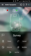
Your mobile Topographer!
The leading tool for the professional surveyor or anyone who wants to mark his property, offering the best accuracy and extensive functionality that no other app can!
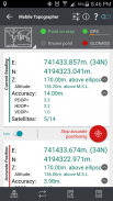
*** Increase GPS accuracy using:
- Weighted averaging (on every axis).
- Map calibration.
- Device calibration on map, or on a know point.
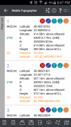
*** Display and convert GPS geodetic to Cartesian EN coordinates and back:
- UTM.
- Europe ETRS89/UTMZ28-38.
- Hellas HGRS 87 (EGSA 87).
- Hellas HGRS 87 - HEPOS.
- Hellas HTRS07/TM07.
- Iceland ISN93/Lambert 93.
- Morocco Merchich.
- SPCS83 (124 zones) USA.
- Romania S-42(58)/Stereo 70.
- Lebanon & Syria Deir ez Zor/Stereo.
- Croatia HTRS96/TM.
- Serbia SRB-ETRS89/UTM, SRB-MGI/Z7.
- Australia MGA94 (GDA94), AMG66 (AGD66) National, A.C.T., Northern Territory, NSW & Victoria, Tasmania,AMG84 (AGD84).
- Former FR of Yugoslavia MGI Balkans zones 5,6 & 7.
- Italy Monte Mario West Zone 1 Peninsular, West Zone 1 Sardinia, East Zone 2 Peninsular, East Zone 2 Sicily.
- Costa Rica CΜ05/CRTM05, Ocotepeque 1935 Costa Rica Norte & Ocotepeque 1935 Costa Rica Sur.
- Cyprus CGRS-93-LTM.
- Hungary HD72/EOV.
- Kosovo KosovaREF01.
- Latvia LKS92/TM.
- Lithuania LKS94/TM.
- Spain ED50/UTMZ29-30 NW, ED50/UTMZ29-31 ML & ED50/UTMZ31 BA.
- Uk's OSTN02/OSGM02.
- Turkey ED50/Gauss-Kruger 3° Z9-15, ITRF96 & ED50/UTMZ35-38.
- Luxembourg LUREF.
- Venezuala REGVEN/Z18-20.
- Sweden SWEREF99 TM.
- Argentina POSGAR 94 & POSGAR 2007.
- India Kalianpur 1975 ZI - ZIV.
- Algeria Nord Sahara 1959 / Z29-32.
- Armenia, Georgia, Azerbaijan, Estonia, Latvia, Lithuania, Russia - Kaliningrad and Kazakhstan Pulkovo 1942/ CS63 (A)Z1-4, (C)Z0-2, (K)Z2-4.
- Central and South America SIRGAS 2000.
- Nigeria and Cameroon Minna 1996 & 2008 MTM West, Mid, East Belts & UTM Z31-33.
- Bangladesh Gulshan 303/TM.
- France RGF93/CC42-50.
- Canada CSRS
- Egypt 1907 Blue, Red, Purple, Extended Purple belts.
- Portugal ETRS89/PTM06.
- Netherlands Amersfoort/RD new.
- Qatar QND95.
- Colombia MAGNA-SIRGAS Far West, West, Bogota, Central East, East zones.
- Mexico ITRF 2008/LCC.
- Madagascar Tananariva (Paris)/Laborde & Tananariva/UTM Z38-39S .
- Tunisia Carthage (Paris)/Mining Grid, Carthage/Nord, Carthage/Sud, Carthage/TM 11 NE, Carthage/UTM zone 32N.
- Liechtenstein CH1903/LV03C-G.
- Switzerland CH1903/LV03 (old), CH1903+/LV95 (new).
- Brazil SAD69/UTM Z18-25 & SAD69(96)/UTM Z18-25
- Spain Canary Islands REGCAN95/LAEA & REGCAN95/LCC & REGCAN95/UTM Z27-28
*** Auto stop for accurate positioning.
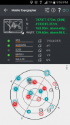
*** Examine the satellites above you in a sky view.
*** Signal strength and number of satellites indication for each GNSS constellation individually.
*** Multiple units support:
- Meters,
- International feet,
- US survey feet.
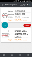
***Height calculation:
- Ellipsoidal height.
- EGM96 orthometric height calculation.
*** Convert from geodetic to Cartesian coordinates and back:
- Support for device measured points, or
- Manually input of geodetic or Cartesian coords.
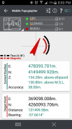
*** Drive me:
- Key in coordinates of the target point in either geodetic or Cartesian coordinates, or select a point from the list and follow the pointer.
- Compass indicating both magnetic and true North.
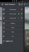
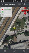
*** Project on Map:
- Project individual points on any map application.
- Project list of points, and the defined polygon, on embedded maps.
*** Save multiple point lists, to use them later.
*** Calculate area.
*** Export point lists το:
- .txt (text file)
- .csv (point file - comma separated)
- .kml (google earth file)
- .gpx (Gps Exchange format)
- .dxf (drawing file)
*** Send file via e-mail, or upload it to cloud.
*** Complete help text support.
Help us improve Mobile Topographer by e-mailing your comments and suggestions.
TAGS: Survey Surveyor Property GPS GNSS GLONASS QZSS BEIDOU GALILEO
Cep Topoğraf!
Profesyonel kadastrocu veya onun mülkiyet işaretlemek isteyen herkes için önemli bir araç, en iyi doğruluk ve başka hiçbir uygulama olabilir ve geniş işlevselliği sunan!
kullanarak *** artırın GPS doğruluğu:
- (Her eksende) ortalamasını Ağırlıklı.
- Harita kalibrasyonu.
- Harita üzerinde veya know noktasında Cihaz kalibrasyonu.
*** Kartezyen EN görüntüleme ve GPS jeodezik çekmeler dönüştürmek koordinatları ve arka:
- UTM.
- Avrupa ETRS89 / UTMZ28-38.
- Hellas HGRS 87 (EGSA 87).
- Hellas HGRS 87 - HEPOS.
- Hellas HTRS07 / TM07.
- İzlanda ISN93 / Lambert 93.
- Fas Merchich.
- SPCS83 (124 bölgeler) ABD.
- Romanya S-42 (58) / Stereo 70.
- Lübnan ve Suriye Deyr ez Zor / Stereo.
- Hırvatistan HTRS96 / TM.
- Sırbistan SRB-ETRS89 / UTM, SRB-MGI / Z7.
- Avustralya MGA94 (GDA94), AMG66 (AGD66) Milli, A.C.T., Northern Territory, NSW ve Victoria, Tazmanya, AMG84 (AGD84).
- Yugoslavya MGI Balkanlar bölgeleri 5,6 ve 7 eski FR.
- İtalya Monte Mario Batı Bölgesi 1. Yarımada, Batı Bölgesi 1. Sardinya, Doğu Bölge 2 Yarımada, Doğu Bölge 2 Sicilya.
- Kosta Rika CΜ05 / CRTM05, Ocotepeque 1935 Kosta Rika Norte & Ocotepeque 1935 Kosta Rika Sur.
- Kıbrıs CGRS-93-LTM.
- Macaristan HD72 / EOV.
- Kosova KosovaREF01.
- Letonya LKS92 / TM.
- Litvanya LKS94 / TM.
- İspanya ED50 / UTMZ29-30 NW, ED50 / UTMZ29-31 ML ve ED50 / UTMZ31 BA.
- İngiltere'nin OSTN02 / OSGM02.
- Türkiye ED50 / Gauss-Kruger 3 ° Z9-15, ITRF96 & ED50 / UTMZ35-38.
- Lüksemburg LUREF.
- Venezuala REGVEN / Z18-20.
- İsveç SWEREF99 TM.
- Arjantin POSGAR 94 & POSGAR 2007.
- Hindistan Kalianpur 1975 ZI - ZIV.
- Cezayir Nord Sahara 1959 / Z29-32.
- Ermenistan, Gürcistan, Azerbaycan, Estonya, Letonya, Litvanya, Rusya - Kaliningrad ve Kazakistan Pulkovo 1942 / CS63 (A) Z1-4, (C) Z0-2, (K) Z2-4.
- Orta ve Güney Amerika SIRGAS 2000.
- Nijerya ve Kamerun Minna 1996 ve 2008 MTM Batı, Orta, Doğu Kemerler ve UTM Z31-33.
- Bangladeş Gülşen 303 / TM.
- Fransa RGF93 / CC42-50.
- Kanada SGRS
- Mısır 1907 Mavi, Kırmızı, Mor, Mor kemer Genişletilmiş.
- Portekiz ETRS89 / PTM06.
- Yeni Hollanda Amersfoort / RD.
- Katar QND95.
- Kolombiya MAGNA-SIRGAS Uzak Batı, Batı, Bogota, Orta Doğu, Doğu bölgeleri.
- Meksika ITRF 2008 / LCC.
- Madagaskar Tananariva (Paris) / Laborde ve Tananariva / UTM Z38-39S.
- Tunus Kartaca (Paris) / Madencilik Izgara, Kartaca / Nord, Kartaca / Sud, Kartaca / TM 11 NE, Carthage / UTM bölge 32N.
- Liechtenstein CH1903 / LV03C-G.
- (Eski) İsviçre CH1903 / LV03, (yeni) CH1903 + / LV95.
- Brezilya SAD69 / UTM Z18-25 ve SAD69 (96) / UTM Z18-25
- Kanarya Adaları REGCAN95 / LAEA ve REGCAN95 / LCC ve REGCAN95 / UTM Z27-28
*** Doğru konumlandırma için Otomatik stop.
*** Bir gökyüzü görünümü yukarıdaki uydular inceleyin.
*** Sinyal gücü ve tek tek her GNSS takımyıldızı için uydular endikasyon sayısı.
*** Birden birimleri destekler:
- Metre,
- Uluslararası ayaklar,
- ABD anket ayakları.
*** Yükseklik hesaplama:
- Elipsoit yüksekliği.
- EGM96 ortometrik yükseklik hesaplama.
*** Geri Kartezyen koordinatlarda ve jeodezik dönüştürme:
- Cihaz için destek ölçülen noktaları, ya da
- Jeodezik veya Kartezyen coords El ile giriş.
*** Bana Drive:
- Jeodezik veya Kartezyen ya koordinatlarda hedef noktasının koordinatları girin veya listeden bir nokta seçin ve işaretçiyi takip edin.
- Manyetik ve gerçek hem de Kuzey belirten Pusula.
*** Haritada Projesi:
- Herhangi bir harita uygulaması Projesi bireysel puan.
- Proje noktalarının listesi ve gömülü haritalarda belirlenen poligon.
*** Daha sonra bunları kullanmak için, çoklu nokta listeleri kaydedin.
*** Alanını hesaplayınız.
*** İhracat noktası listeleri: Icecat
- .txt (Metin dosyası)
- .csv (Nokta dosyası - virgülle ayrılmış)
- .kml (Google earth dosyası)
- .gpx (GPS Değişim Formatı)
- .dxf (Çizim dosyası)
*** E-posta yoluyla dosya gönder, ya da bulut yükleyin.
*** Komple yardım metin desteği.
Bize e-posta göndererek görüş ve önerilerinizi Mobile Topoğraf geliştirmemize yardımcı olun.
Etiketler: Anket Surveyor Mülkiyet GPS GNSS GLONASS QZSS Beidou GALILEO
Mobile Topographer Free - Sürüm 9.3.2
(22-05-2019)

Mobile Topographer Free - APK Bilgisi
APK sürümü: 9.3.2Paket: gr.stasta.mobiletopographerMobile Topographer Free uygulamasının en son sürümü
Diğer sürümler


 3.67
3.67

 3.78
3.78


Aynı kategorideki uygulamalar

Hoşuna gidebilecekler...


